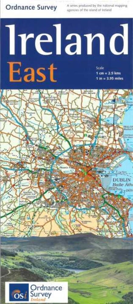
ORDNANCE SURVEY IERLAND IERLAND OOST HOLIDAY MAP 1:250.000 (9781908852854)

OMSCHRIJVING
Ordnance Survey Ireland East Road map at 1:250,000 approx 4 miles to the Inch.
This map shows detailed road classification, altitude colouring and tourist information, published by OSI, the Ordnance Survey of Ireland.
Topography of the island is shown by altitude colouring, with additional spot heights and names of mountain or hill ranges and other geographical features.
Additional graphics show different types of woodlands etc.
Road network shows six grades of roads;
Railway lines are shown with stations.
A range of symbols highlights camping and caravan sites, nature reserves, National Trust and An Taisce properties or land, golf courses (indicating the number of holes), historical sites, etc.
The maps have 10-km Irish national grid, plus latitude and longitude margin ticks at 10 intervals.
No index is provided.Ordnance Survey Ireland East Road map at 1:250,000 approx 4 miles to the Inch.
This map shows detailed road classification, altitude colouring and tourist information, published by OSI, the Ordnance Survey of Ireland.
Topography of the island is shown by altitude colouring, with additional spot heights and names of mountain or hill ranges and other geographical features.
Additional graphics show different types of woodlands etc.
Road network shows six grades of roads; Railway lines are shown with stations.
A range of symbols highlights camping and caravan sites, nature reserves, National Trust and An Taisce properties or land, golf courses (indicating the number of holes), historical sites, etc.
The maps have 10-km Irish national grid, plus latitude and longitude margin ticks at 10 intervals.
No index is provided.
Bekijk alle Europa
OMSCHRIJVING
This map shows detailed road classification, altitude colouring and tourist information, published by OSI, the Ordnance Survey of Ireland.
Topography of the island is shown by altitude colouring, with additional spot heights and names of mountain or hill ranges and other geographical features.
Additional graphics show different types of woodlands etc.
Road network shows six grades of roads;
Railway lines are shown with stations.
A range of symbols highlights camping and caravan sites, nature reserves, National Trust and An Taisce properties or land, golf courses (indicating the number of holes), historical sites, etc.
The maps have 10-km Irish national grid, plus latitude and longitude margin ticks at 10 intervals.
No index is provided.Ordnance Survey Ireland East Road map at 1:250,000 approx 4 miles to the Inch.
This map shows detailed road classification, altitude colouring and tourist information, published by OSI, the Ordnance Survey of Ireland.
Topography of the island is shown by altitude colouring, with additional spot heights and names of mountain or hill ranges and other geographical features.
Additional graphics show different types of woodlands etc.
Road network shows six grades of roads; Railway lines are shown with stations.
A range of symbols highlights camping and caravan sites, nature reserves, National Trust and An Taisce properties or land, golf courses (indicating the number of holes), historical sites, etc.
The maps have 10-km Irish national grid, plus latitude and longitude margin ticks at 10 intervals.
No index is provided.
Bekijk alle Europa
PRODUCTINFORMATIE ORDNANCE SURVEY IERLAND IERLAND OOST HOLIDAY MAP 1:250.000
PRODUCTINFORMATIE ORDNANCE SURVEY IERLAND IERLAND OOST HOLIDAY MAP 1:250.000
HET MERK ORDNANCE SURVEY IERLAND
Met de topografische kaarten van Ordnance Survey of Ireland is het lastig verdwalen. Deze uitstekende wandelkaarten worden in samenspraak met de Noord-Ierse Cartografische Dienst, OSNI gemaakt. Als u op vakantie gaat naar Ierland en graag een wandeling wilt maken in de Wicklow Mountains of een fietstocht heeft gepland door de Nationale Parken Connemara of Killarney in County Kerry of County Donegal, bieden de kaarten van Ordance Survey Ireland een schat aan informatie.
GARANTIE
Of u het product online via de webshop of in onze fysieke winkel gekocht heeft, de garantie is voor Zwerfkei hetzelfde. De garantietermijn kan per product en merk verschillen, van één jaar tot de volledige levensduur van het product. Garantie geldt in principe op alle materiaal- en/of fabricagefouten, en niet op defecten als gevolg van slijtage of verkeerd gebruik. In het geval van garantie wordt het defecte product vervangen, vergoed of hersteld door de fabrikant/importeur of door een professionele en gespecialiseerde reparateur.
Zwerfkei verzorgt de begeleiding en de afhandeling van garantiegevallen voor u. Wij bieden het product na beoordeling ter reparatie aan bij de fabrikant/importeur of één van hun professionele servicediensten. Wij onderhouden goede contacten met onze servicediensten en samen zorgen wij ervoor dat elk defect zo snel mogelijk opgelost wordt.
ORDNANCE SURVEY IERLAND IERLAND OOST HOLIDAY MAP 1:250.000 KOPEN?
KEUZEHULP
OPENINGSTIJDEN
| Ma | 13:00 - 18:00 uur |
| Di | 09:00 - 18:00 uur |
| Wo | 09:00 - 18:00 uur |
| Do | 09:00 - 18:00 uur |
| Vr | 09:00 - 21:00 uur |
| Za | 09:00 - 17:00 uur |
| Zo | gesloten |
3446 CR Woerden
0348-421648
ANDERE KLANTEN KOCHTEN OOK